
Heritage: A story still unfolding

I am a living story of resilience, culture and tradition — shared through my people and our history.
For more than 25 000 years, people have lived in this area — leaving traces of their lives in stone tools, rock paintings and stories carried through generations. The Prince Albert district holds a rich record of Later Stone Age sites, with evidence of Middle Stone Age people found at Boomplaas Cave on the Swartberg Pass. Some tools were still being made and used by the San and Khoikhoi when Europeans first arrived — offering rare, eye-witness insight into both their practical and symbolic lives.
The Khoikhoi were pastoralists, moving with their herds of sheep and goats in search of grazing and water. The very name Karoo comes from their word Karusa — meaning “dry, arid place.”
European settlers began arriving after 1652, and the area’s first loan farm, Kweekvallei (“valley of cultivation and plenty”), was granted in 1762. When the Dutch Reformed Church bought part of the land for a church, the small settlement began to grow — and in 1845 it was proclaimed Prince Albert, in honour of Queen Victoria’s consort.
Today, the town stands as the heart of a district that includes Klaarstroom, Prince Albert Road and Leeu-Gamka — home to more than 17 000 people who continue to live, farm and tell the stories of this extraordinary Karoo valley.
Through the years many people have played their part in shaping our history – contributing to our deeply rooted and much-loved heritage.
Ek is Alfred Voetpad. Ek is gebore in Kimberley in 1932 maar het grootgeraak op Middelburg in die Oos Kaap. Ek was een van nege kinders van ‘n kleurling vrou en ‘n Xhosa man. My pa was ‘n plaaswerker van bees, skaap en bokke. Ek was ‘n jong sterk man toe ons Karoo toe getrek het en op Koppies Kraal buite Prince Albert aangekom het, en toe ‘n paar jaar later in die dorp kom bly het. Ek was in my vroeë twintigs toe ek vir ‘n ruk in die Kaap gaan woon het en by ‘n hotel in Worcester werk gekry het, maar ek moes terugkom Lap toe om na my ma-le te kom kyk.
Prince Albert het my huis geword – ’n stil dorp met goeie mense. Hier het ek en my vrou vyf kinders grootgemaak. Ek het as ambagsman en bouer gewerk en het na die instandhouding van die Zwartberg Hoerskool en later die Polisie stasie omgesien. Dis by die polisie waar ek later jare op pensioen gegaan het.
Ek het vir Jan Schoeman, of Outa Lappies soos die dorp hom geken het, ontmoet. Ek het hom een keer hoor praat, het tot bekering gekom en is groot gedoop in die dam agter die BP Garage op 1 April 1956. Ek en hy het saam die AGS Kerk begin en gebou, en ek is vandag die oudste lidmaat. Ek was ook die gemeenskap verteenwoordig toe ons Pretoria toe kon gaan om restitusie te kry vir die huise wat ons kleurling mense verloor het by die uitsettings van 1968 tot 1972.
Dit was toe al ons mense geskuif was van Rooikamp in die dorp na Noord-Einde – waar ons vandag nog bly.
Ek het tot so paar jaar terug nog atletiek gehardloop in die Golden Games vir bejaardes, maar deesdae hou ek my besig by my huis en ek stap kerk toe om dit te gaan netjies hou. My drie dogters en kleinkinders bly naby en ek sien hulle elke dag. Ek is dankbaar vir ‘n lewe vol geloof en familie.
Ek was lankal terug miskien ‘n inkommer maar my storie lé diep gewortel in die grond en die mense van hierdie dorp.
From Queekvaleij to Prince Albert

A view from the Koppie
The original drawing by explorer Robert Gordon of the farm Queekvaleij (now the town of Prince Albert). He sketched the scene from the lookout point which is now Gordon’s Koppie.
Image: Rijksmuseum, Netherlands

A Living Story of a Karoo Town
At the heart of the Great Karoo lies a town with deep roots — a place where stories of people and perseverance intertwine. Long before the name Prince Albert appeared on any map, this valley was known as Queekvaleij (Kweekvallei), “the valley of cultivation and plenty.”
Image: The start of a town. The original diagram indicating the sub division of smaller farms, dated 1830.
The Birth of Kweekvallei
In 1762, a farmer named Zacharias de Beer was granted a loan farm , drawn by the fertile soils and reliable spring water that trickled down from the Swartberg Mountains. In a semi-desert landscape, this abundance made Kweekvallei exceptional: a small oasis where crops could grow and livestock could thrive.
Over time, other settlers followed, drawn by the same promise of water and fertile land. Families established smallholdings, planted orchards, and built homes along the leiwater channels that still run through the town today.
A Village Takes Shape
By the 1820s, Kweekvallei had become more than a farm — it was a growing community. The land was surveyed and subdivided into plots, marking the first step towards formal settlement. In 1842, the Dutch Reformed Church Synod approved the purchase of a portion of Kweekvallei to build a church, giving the village its spiritual and social centre.
Just a few years later, in 1845, the little settlement was officially proclaimed Prince Albert, in honour of Queen Victoria’s consort. Early residents had even considered the name Albertsburg before settling on the name we know today.
Water, Work and the Will to Endure
Water has always been at the centre of life here. The early leiwater system — hand-built furrows that carried mountain spring water to homes and gardens — became the town’s lifeline. In 1939, the Kweekvallei Irrigation Board was formalised to manage this precious resource, a system that still shapes the town’s rhythm and landscape.
Through the 19th century, the community grew steadily. In 1849, the first post office opened, and by 1852 a school was established. Agriculture remained the backbone of life, and when the Swartberg Pass was completed in the 1880s, it connected Prince Albert to the Klein Karoo, bringing trade and travellers over the mountains.
Faith, Fortitude and Community
The Dutch Reformed Church, established in 1842, completed in 1865, is a key landmark and national monument. Around it, generations of residents built a life of resilience and quiet dignity, weathering droughts, floods and the shifting fortunes of the Karoo.
In time, the arrival of the railway at Prince Albert Road extended the town’s reach to the wider world, while still preserving its character as a close-knit farming community.
A Heritage of Heart
Today, Prince Albert stands as a municipality that includes Klaarstroom, Leeu-Gamka, and Prince Albert Road, home to more than 17 000 residents. Its 250-year history — celebrated in 2012 — is not merely written in archives, but is told in the lived experiences of its people, the architecture that lines its streets, and the enduring rhythm of water flowing through the leiwater channels.
From its beginnings as a single Karoo farm, Prince Albert has become a living story of heritage, heart and belonging — where the past still whispers through the stones, and every new chapter is shaped by the hands of its people.
More information
- Fransie Pienaar Museum (link to PATA web page): various articles and mentions exists online, but visit the museum to view a range of exabits – from stone age artifacts to a room dedicated to a local artist and community leader “Outa Lappies”.
- The Story Weaver: contact Ailsa Tudhope to join her on one of her historical excursions: 084 673 1710 or e-mail: story@storyweaver.co.za
The Prince Albert Heritage Trail: A Living Story of Stone, Faith and Resilience
A proud landmark is the NG Kerk (Dutch Reformed Church), also a national monument. Its 1886 English-built organ, adorned with gold-leaf pipes, still fills the church with the same rich sound that first rang out more than a century ago.
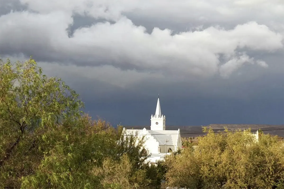


The NG Kerk stands at the heart of the town’s life and skyline for more than 160 years. Its foundation stone was laid in 1860, and the church was inaugurated five years later, built in the elegant Neo-Gothic style that was popular among rural congregations of the time. With its whitewashed walls, pointed arches and tall spire, the building became a beacon of faith visible across the plains of the Great Karoo, reflecting both the steadfastness and the simplicity of the community it served.
Over the years the church has witnessed baptisms, weddings and farewells that together tell the story of Prince Albert’s people. It has survived droughts, prosperity and change, remaining a place of worship and gathering for generations. The NG Kerk continues to embody the spirit of resilience and belonging that defines the town — a reminder of how faith, architecture and community are woven together in the living story of the Karoo.
Photographs: Inga Terblanche, Dianne Freemantle, Karin Henriques. Featured are the annual Church Bazaar and Johan Badenhorst, the Koster who has been taking care of the church for years.
Our Heritage Trail
Walk through time where specific landmarks hold stories of endurance, connection and quiet beauty.
The following is a list of officially declared provincial heritage sites and other buildings that have been noted for their historic significance. Most are private residences but many can be seen from the road, of which ten are on the Main Road.
(*Note: The officially declared buildings are former national monuments that have been incorporated into the provincial heritage register)
Vrolikheid Farmhouse (1821)
A quiet farmstead capturing generations of Karoo farmers and their deep connection to the land. The farm had a licence to (stook) distil witblits.
*Declared in 1976
Dennehof, (1835)
Thought to be Prince Albert’s oldest building — a thatched, thick-walled farmhouse where the town’s story truly begins. It’s now a guesthouse, voted 6th best in Africa in 2025.
*Declared in 1997
Albert’s Mill, Christina de Wit Street (1850)
Built by H.J. Botes, this beautifully restored water mill tells of early ingenuity and the town’s agricultural beginnings. It is one of the oldest surviving mills in the Karoo.
*Declared in 1966
Old Doctor’s House, 15 Church Street (1850)
Home and surgery of the town’s physician — its rooms still whisper stories of care and compassion.
Old Mission Church Parsonage, 5 Church Street (1858)
A gracious home reflecting a time when faith and service shaped community life.
*Declared in 1985
Dutch Reformed Church & Hall, Church Street (1860)
The town’s skyline centrepiece — a place of worship, music and gathering for over a century. The cornerstone was laid on 1 Oct 1860, consecrated in 1865; the hall followed later.
*Declared in 1988
Swartberg Hotel, 77 Church Street (1864)
This landmark has welcomed travellers with Victorian grace and small-town warmth.
*Declared in 1989
57 Church Street (1865)
Built as a home in 1865 it later became a boarding house and in 1985 became known as the Seven Arches. With its graceful arches and symmetry, this home is one of the town’s most photographed icons.
*Declared in 1987
Helmuth House, 20 Church Street (1885)
Linked to the town’s historic leibeurt water system — where neighbours shared life-giving water in a dry land. A double story house on one of Prince Albert’s existing town farms. It also has a beautiful barn.
*Declared in 1986
26 Church Street (corner Pastorie Street) (1860)
A finely preserved example of 19th-century craftsmanship. It was built in 1860 as a general dealer’s store. In the early 1900’s J C Forsyth owned it for 50 years and it was known as Forsyth’s Store. It was a well-loved shop and he stocked everything from farm equipment to the finest ladies lace. Now home to PEP.
*Declared in 1996
Swartberg Pass (1881-1888)
Thomas Bain’s 28 km masterpiece carved through solid rock — one of the world’s great mountain passes.
Did you know? Built using pickaxes and black powder, it took eight years to complete and the final cost for the construction of the Swartberg Pass was £14 500, excluding convict labour worth £17 000. It officially opened on 10 January 1888 – the first all-weather link between Prince Albert and the Great Karoo to Oudtshoorn and the port of Mossel Bay.
*Declared in 1989
Dutch Reformed Church Parsonage, 2 Pastorie street (1893)
Once home to generations of ministers, it reflects the dignity of Karoo town life.
*Declared in 1988
St John the Baptist Anglican Church & Hall, Bank Street (1895, consecrated 1896)
An English-Gothic church whose simple beauty still offers calm and contemplation. The hall dates from 1872 and was originally used as their missionary school.
*Declared in 1997
Bona Vista, 7 Pastorie Street (1904)
This house was built by F S Oosthuizen, a very wealthy farmer, as his townhouse for when they came to attend church. Its shady verandas and bay windows are quintessential to this home’s Victorian architectural charm.
*Declared in 1986
Dutch Reformed Church, Zeekoegat (1906, consecrated in 1907)
A simple country church surrounded by farmland — a steadfast symbol of faith and endurance, built F S Oosthuizen and donated to the Prince Albert Dutch Reformed Church.
*Declared in 1984
Parliamentarian’s house 2 Church Street (1850)
The house was built by Jan Luttig on his town farm. He was a parliamentarian for the Beaufort West constituency and was the first to deliver a speech in Dutch in the Cape Parliament in 1882. The property was known as Vergelegen. The house has a beautiful Burmese trellis around the stoep.
*Declared in 1986
Baviaanskloof Farmhouse (1837)
The house has four gables – the most striking and ornamental in the Prince Albert area.
*Declared in 1976
Gamkaskloof (1830)
Hidden deep within the Swartberg Mountains, Gamkaskloof — affectionately known as Die Hel — is a narrow valley about 20 km long and 600 m wide. From 1830, a small, self-sufficient farming community lived here in near isolation, with access only by footpaths along the Gamka River and a steep route known as Die Leer. In 1962, a spectacular gravel road was carved into the mountain from the Swartberg Pass — a 37 km journey that winds through dramatic switchbacks and takes around two hours to drive each way. Today the road and the restored valley homesteads form part of the Swartberg Nature Reserve, offering one of the most scenic and historic drives in South Africa.
*Declared in 1997
Leeu Gamka
Railway Quarters & Station Buildings, Leeu Gamka (late 19th century)
Sturdy stone cottages that recall the time when the railway brought life and trade to the Great Karoo. It was also used as convalescent quarters during the Anglo-Boer War.
Leeu Gamka Hotel (1898)
Once a welcome stop for weary travellers along the railway, this gracious hotel is now a welcome stop for travellers along the N1 and still carries the frontier charm of the old Karoo.
Blockhouse Ruins on the Leeu River (1901)
Silent reminders of the Anglo-Boer War, these ruins once guarded the vital railway bridge.
Dutch Reformed Church, Leeu Gamka (1922)
Built from local stone, this small church has long stood at the heart of the Leeu Gamka community.
Klaarstroom
Historic Karoo Stone & Dagha Houses, Klaarstroom (from 1840s)
These stoep-fronted homes, built from stone and clay, speak of resilience in the face of the Karoo’s extremes.
Corbeel House, Farm Haggas, Klaarstroom (19th century)
Its carved corbels and broad gable reveal the artistry of early Karoo builders.
Did you know? “Corbeel” refers to the carved wooden supports under its eaves — a unique architectural flourish.
Church of the Good Shepherd (1895)
A charming sandstone chapel whose simple beauty and quiet setting capture the timeless grace of Karoo village life.
Both Leeu Gamka and Klaarstroom have Anglo Boer War graves.
Other notable buildings and places:
- NG Kerk Begraafplaas (1844 – 1884)
- Onse Rus, 22 Church Street (early to mid 1800’s, with the gable being dated 1852) A gracious late-Victorian home once listed as a national monument, capturing the warmth and elegance of old-world living. One of the famous stops on the Ghost walk. (uncertain about actual heritage listing – need to verify). Was never declared a monument. Over the years the P A Cultural Foundation has awarded plaques or certificates to buildings that have been restored.
- Parliamentarian’s House – Vergelegen (c.1850) Built by Jan Luttig, Member of Parliament for the Beaufort West constituency and the first to deliver a speech in Dutch in the Cape Parliament (1882), this elegant home at 2 Church Street — known as Vergelegen — reflects the prosperity and stature of 19th-century Prince Albert. Its distinctive four gables and intricate Burmese trelliswork remain among the town’s finest architectural features.
- Zeekoegat Farmstead (before 1868)
- Zwartberg High School (1897)
- Fransie Pienaar Museum (1906) Built in 1906 by Jan Haak, the Fransie Pienaar Museum captures the rich history of Prince Albert and its surrounding area. The building also served as a hospital before being purchased by the municipality in the early 1980s to house the museum. Today it tells the story of the town through historical exhibits, artefacts and local art — including works by the renowned outsider artist Outa Lappies (Jan Schoeman). The museum also operates as the town’s archive and proudly holds a licence to distil witblits and mampoer, a tradition celebrated every April. The on-site shop offers a selection of books and locally inspired gifts for visitors.
- NG Zending Kerk (1906)
- Public Buildings: The building housing the Municipal Manager and other municipal offices was the original Standard Bank building designed by the famous architect Sir Herbert Baker who also designed the Union Buildings in Pretoria.
- Petrol station (now Kredouw House with retail space) (1944)
- Gamkapoort Dam (1969)
- House Sally (2002)
- The Showroom: The Showroom was originally a house later converted to a shop and then a petrol station and a car showroom. I can look up the dates at the museum.
- VGK Primary School, Zeekoegat
Further reading:
- KLAARSTROOM Ancient place of clear waters By Rose Willis and Doreen Atkinson With Judy Maguire and Bruce Rubidge
- Artefacts Online listings site
- Western Cape Provincial Heritage Sites
- Karoo South Africa David Frandsen
- Historical Route Pamphlet is for sale at the Museum